Their people have worked hard to preserve historic buildings. There seem to be plenty of museums that display history. As Fairbanks grew into a modern city, locals organized groups to save historic places, i.e. log cabins, churches, homes, historic planes, snowmobiles, even part of the sternwheeler that brought E.T.Barnette, founding father, to Fairbanks. Some cabins located in Pioneer Park have signs that name the original Gold Rush owners.
Friday evening, the night before we began the land portion of our tour, the five of us took a shuttle to 796 Chena Pump Road to the Pump House Restaurant and Saloon overlooking the Chena River in Fairbanks.
(Note: You can click on any photo to enlarge it, and simply click the x to close it.)
 |
| Pump House Restaurant and Saloon |
 |
| Saloon Entrance |
 |
| Pulling at your heart strings |
 |
| Park area across sidewalk from entrance |
 |
| Water cannon shooting water into Chena River |
 |
| Entrance to inside dining room |
 |
| A dredging scoop turned into a planter. |
It was a little unusual to see a dog team and musher with a chef’s hat mounted upside down on the ceiling. As we were looking at the menu, my sister read that they were there in memory of their chef -- apparently, he was a musher who had not had a vacation in a while, and this time when he went on vacation, met with an accident that took his life.
 |
| In memory of Chef and his Dog Sled Team |
 |
| In memory of Musher Chef and his Dog Sled Team |
Alaska is the largest state in the country.
With a land area of 570,374 square miles, it is about one-fifth the size, or twenty percent, of the Lower 48 states. Its motto is North to the Future. It became the 49th state on January 3, 1959. When the United States purchased Alaska in 1867, we paid Russia $7.2 million, approximately $0.02 per acre.
Land Portion of our Tour Kicks Off
Saturday (June 4), our day started with a tour of Fairbanks. We boarded our comfy coach named Prospector and headed north to a place where we got off to view a portion of the Alyeska Pipeline.
Alyeska Pipeline
The Trans Alaska Pipeline System is 800 miles long. It begins in Prudhoe Bay (Alaska’s north slope), and stretches to Valdez, the northernmost ice-free port in North America, through rugged and beautiful terrain. It is one of the world’s largest pipeline systems. When constructed in the 1970s, it was an engineering icon that was the biggest privately funded construction project.
 |
| Alyeska Pipeline (first view entering from highway) |
 |
| Alyeska Pipeline from opposite side |
 |
| Alyeska Pipeline looking to North |
 |
| Pipeline runs N to S from Prudhoe Bay to Valdez |
 |
| James A Maple, P.E. Arctic Pipeline Engineer |
"In recognition of his contribution to the engineering of arctic pipelines, Dr. Maple was awarded the prestigious Harold R. Peyton Award for Cold Regions Engineering by the American Society of Civil Engineers in 2001. The award was named for Dr. Peyton, another key pipeline designer, who unfortunately died just before the pipeline was commissioned in 1977.
"Dedicated August 1, 2002 in commemoration of the 25th anniversary of the opening of the trans-Alaska pipeline."
 |
| American Welding Society outstanding development in welded fabrication award |
 |
| View of Pig in the Pipeline |
 |
| Pigs in the Pipeline |
 |
| Retired Pig |
 |
| Retired Pig used in the Pipeline |
Fairbanks Gold Rush
The story has it that in 1901 E. T. Barnette, a trader, and his wife, Isabelle, were on the riverboat, the Lavelle Young. They wanted to set up a trading post at Tanacross on the Tanana River. Before they reached their destination, low water conditions existed, and Captain Charles Adams, co-owner of the boat turned into the Chena River, a tributary of the Tanana River. Due to shallow water, the Lavelle Young stopped, and Adams refused to go any farther, so Barnette had to unload everything there.
Meanwhile in July 1902, Felix Pedro discovered gold north of Fairbanks in Interior Alaska, told Barnette, so Barnette opened his trading post. In order for Barnette to create a market for his goods, he then dispatched a Japanese immigrant to go to Dawson City to tell them gold had been found. The miners who went to Fairbanks soon found themselves working for Barnette – prospecting for gold by panning and sluicing for gold in Fairbanks.
Next Stop: Fred Meyer
Before we headed to downtown Fairbanks, we stopped at Fred Meyer in Fairbanks. This seemed a little strange to us, at the time. I had never visited a Fred Meyer store before, and was not sure I saw a need to do it in Fairbanks, but, oh well. As it was explained to us, this would be one of the last places where we could stock up on anything we might need. We had thirty minutes to stock up. The reason given to stock up was the next day after getting off the Alaska Railway, we would board a tan tour bus for Denali National Park. Water would be available on the bus and we would get a box of snacks, but it might be 8PM by the time we got to our night lodging. Find out more about our purchases when you read the post about Denali National Park.
Downtown Fairbanks
After a bus tour of the downtown area, we had several hours to explore. I do not remember all of the choices, except that a good variety of food was available, including a fudge shop. We headed over to the River City Café where we could order from a variety of salad/sandwich/soup choices and have a choice of eating inside or outside.
 |
| River City Cafe and Expresso |
 |
| Gold Rush Jewelry, more eateries and shops |
 |
| World's Largest Int'l Dog Mushing & Sled Museum was on the next street. |
Golden Heart Plaza/Park is located in the middle of Fairbanks along the south banks of the Chena River. In the center of a fountain, which was not running the day I took this photo, is this bronze statue. Plaques were mounted on a raised platform around the fountain area. Patio or paver blocks cover the entire walking area to an outer perimeter where seating is available part of the way around.
 |
| "The First Unknown Family" statue in Golden Heart Plaza. |
Annus Mirabilis
 |
| The Latin translation for "ANNUS MIRABILIS" is "Wonderful Year". |
From above center:
"It was not a year
"It was not a year
Just like other years;
Somehow 'Eighty-Four was special,
As if the hand of God
Had briefly brushed the place
And sparked a miracle."
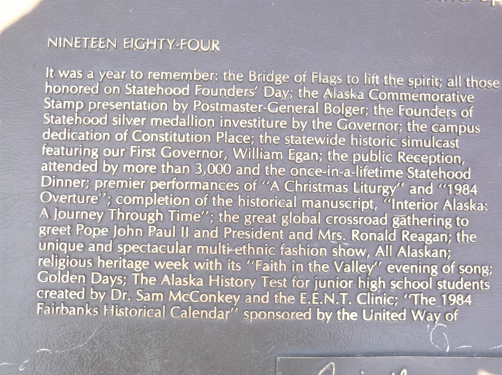
Following are three close-up photos of the plaque in the photo above that explain that 1984 was a year to remember, a year of wonders, for the Alaskan people.
(Note: Click on the picture to see it in a larger version, and simply click on the x to close out of it.)


Putting it all in Perspective
This was Day Four for us. We had already seen many things and were trying to absorb much more. It helps to understand that Fairbanks is the largest town in Interior Alaska. The population of Fairbanks is about 30,000 people, but closer to 100,000 people live in the greater Fairbanks area. Fairbanks serves as a hub for rural interior Alaska, river communities and villages.
When I looked at the Alaska map in the Rand McNally Road Atlas, I got a better understanding of Interior Alaska. Many residents do not have road access to their towns. Two rivers, the Tanana River and the Yukon River, flow into Interior Alaska. Travel for residents without road access is by boat and airplane. People who live along the rivers and the Northern Alaska coastline are predominantly Native American – Yup’ik, Inupiat, and Athabascan. When they come to town, they come to Fairbanks. They consider Anchorage Alaska’s largest village. Every year large conventions are held in Fairbanks and Anchorage, where village residents can celebrate culture and traditional lifestyles.
When the United States originally purchased Alaska, apparently not much was known about the interior of Alaska.
In the 1970’s, highways were built in stages, and until they were connected, they were like roads to nowhere. Today Rand McNally Road Atlas shows:
1) The Parks highway from Fairbanks south to Anchorage on the west,
2) The Richardson Highway from Fairbanks south on the east, and
3) The Glenn Highway connects the Parks and Richardson Highways and also extends on to the Alaskan Highway that many people drive, that also connects to the Richardson Highway at Delta Junction southeast of Fairbanks.
Learning about the modes of transportation available, and the highway system that connects everything, or not, is very important when creating a picture in my mind of the vastness that is Alaska.
Stay tuned – In the next post, my sister and I have a subzero experience and see why Riverboat Discovery was voted the best boat tour in North America!
Thank you everyone for visiting and following my adventure. Feel free to make comments. If you would like to be notified when a new post is published, put your email address in the box at the top right of this blog and be sure to go to your email to confirm your subscription. We respect your privacy and do nothing with your information.
We also appreciate your clicking on any of our links. Any purchase you make when you use our links may generate a small percentage of income from that vendor, but it will not increase any cost to you. This is true no matter how many pages you visit or which item you purchase on a site after initially entering the site from my blog.
No comments:
Post a Comment
We welcome conversational comments that are on topic and useful. Links to personal blogs are fine, but we will not approve comments made for the sole purpose of linking to a commercial business, and/or which have no direct relevancy to the topic of the post. Thank you.